
Europe´s economic prosperity and well-being is underpinned by its natural capital, i.e. its biodiversity, including ecosystems that provide essential goods and services, from fertile soil and multi-functional forests to productive land and seas, from good quality fresh water and clean air to pollination and climate regulation and protection against natural disasters. In the context of the European Green Deal, the EU Biodiversity Strategy for 2030 is calling for the establishment of an international natural capital accounting initiative.
In 2021, the UN adopted a new statistical framework to better account for biodiversity and ecosystems in national economic planning and policy decision-making, allowing countries to use a common set of rules and methods to track changes in ecosystems and their services. The new framework goes beyond the commonly used statistic of gross domestic product (GDP) and ensures that natural capital accounts - the contributions of forests, oceans and other ecosystems—complements existing economic accounts. Moreover, the ecosystem assessment takes a spatial approach to accounting, as the benefits a society receives from ecosystems depend on where those assets are in the landscape in relation to the beneficiaries. This spatial focus identifies the location and size of ecosystem assets, the ecosystem services provided, and the location of beneficiaries (households, businesses and governments).
On behalf of the National Statistical Office space4environment analysed the feasibility of the development of ecosystem extent, service and condition accounts for Luxembourg. The first objective of the project was to review existing data sets which could support the calculation of indicators on ecosystem accounts as defined in a proposal by the Eurostat Task Force on ecosystem accounting. The second aim was to develop a methodology to implement and calculate the respective indicators, including wherever possible geospatial data. For each of the indicators, we present an “indicator fact sheet” which recapitulates the objective, the methodology, potential limitations and results.

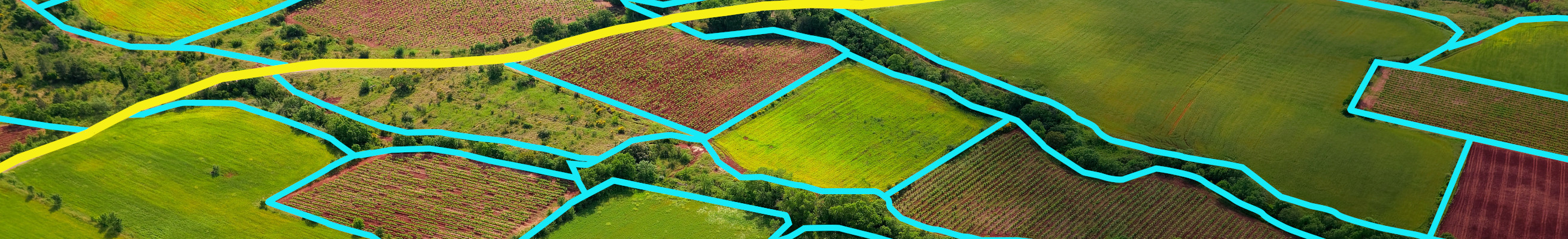
Land use and land use change are fundamental for sustainable resource use and the delivery of ecosystem services, including the provision of food, nutrient cycling and climate change mitigation through carbon sequestration. Land resources are part of our shared natural capital and must be well managed to maintain a healthy environment and human well-being. As such, only if land use and its impacts are properly addressed is progress towards sustainable development in Europe possible. Land-use related policies require the development of harmonised datasets, transparent methodologies and easily interpretable statistics. Land accounts fit the bill, describing how land resource stocks change over time.

Land degradation is recognised as a threat to the European and global ecosystems and their condition, with direct relevance to climate change adaptation, human well-being, food-security and social welfare. However, objectives to halt and revert land degradation are dispersed over a range of strategic documents and policy guidelines at the EU. So are the topics of land and soil, which can be found across policy instruments of various sectors. Therefore, there is a need for a single up-to-date strategic policy framework that preserves and enhances land resources in the European Union.
This report aims at providing an overview of the current knowledge regarding land degradation from different perspectives:

Tree canopy cover describes the area in cities that are covered by the crown of the trees if looked at from above. Possessing sufficient tree cover or increasing the tree cover has multiple benefits. On the one hand, trees contribute to adapting to or mitigating effects that are related to global warming, such as acting as CO2 sink, providing shade to mitigate the Urban Heat Island effect, deflecting strong winds and helping to reduce energy needs. Then, trees benefit mental and physical health, e.g., by reducing the amount of toxic particles in the ambient air or alleviating impacts through heat. Lastly, trees provide habitats for wildlife as well as ecosystem services for the inhabitants and can also increase property values.
On the policy level, trees are key components of the EU Biodiversity Strategy 2030 (BDS2030) and the EU Strategy on Adaptation to Climate Change. In the BDS2030, the importance of trees in cities is acknowledged and cities are requested to set up urban greening plans which should include plans to increase the share and quality of urban green areas, including parks and trees/forests. In addition, the BDS2030 calls for a new EU Forest Strategy foreseen to be published end of 2021 and including the aim to plant 3 billion new trees in the coming years.
The tree canopy coverage that is presented in this viewer includes trees on both public and private land and is based on several Copernicus products. These contain the High-Resolution Layer Tree Cover Density (HRL TCD), the Urban Atlas Land use/Land Cover data and the Urban Atlas Street Tree Layer. The reference year for all products is 2018. The tree canopy coverage is calculated for almost 800 European cities and three different spatial reference units, i.e., the City, the city’s Commuting Zone and the Functional Urban Area (FUA) as the combination of the two. For the calculation of the tree canopy coverage the input data were integrated into a cube system with a common spatial reference from which the final values could be extracted and imported into several dashboards corresponding to the tabs in this viewer.

The ETC/ULS Report on “Integrated accounting of land cover changes and soil functions” is the outcome of a study that was executed between 2013 and 2018 by the EEA and ETC/ULS with support from EIONET (NRCs land use and spatial planning) and the European Soil Data Centre of DG JRC.
The analysis represents the first attempt to assess land use efficiency at a European scale. Several new data sets relating specifically to soil functions, were published only recently, and this made assessment possible. A key aim of this work was to study land cover changes and their positive or negative impacts on soil functions, and to obtain a disaggregated hotspot analysis and an overall balance of those impacts on soil functions.